
Magnitude 4.9 - SANTA CRUZ ISLANDS
2011 September 04 03:43:57 UTC
Earthquake Details
- This event has been reviewed by a seismologist.
| Magnitude | 4.9 |
|---|---|
| Date-Time |
|
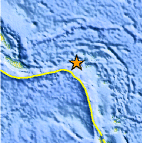
| Location | 10.559°S, 165.282°E |
| Depth | 31.9 km (19.8 miles) |
| Region | SANTA CRUZ ISLANDS |
| Distances | 62 km (38 miles) WNW of Lata, Santa Cruz Islands, Solomon Isl. 368 km (228 miles) E of Kira Kira, San Cristobal, Solomon Isl. 597 km (370 miles) ESE of HONIARA, Guadalcanal, Solomon Islands 2273 km (1412 miles) NE of BRISBANE, Queensland, Australia |
| Location Uncertainty | horizontal +/- 21.7 km (13.5 miles); depth +/- 8.5 km (5.3 miles) |
| Parameters | NST= 68, Nph= 73, Dmin=597.8 km, Rmss=0.74 sec, Gp=104°, M-type=body wave magnitude (Mb), Version=5 |
| Source |
|
| Event ID | usc0005nvy |
- Did you feel it? Report shaking and damage at your location. You can also view a map displaying accumulated data from your report and others.
Earthquake Maps


Scientific & Technical Information
 Historic Moment Tensor Solutions
- Preliminary Earthquake Report
- U.S. Geological Survey, National Earthquake Information Center:
World Data Center for Seismology, Denver
