
Magnitude 4.8 - SOLOMON ISLANDS
2011 September 04 01:27:00 UTC
Earthquake Details
- This event has been reviewed by a seismologist.
| Magnitude | 4.8 |
|---|---|
| Date-Time |
|
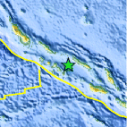
| Location | 8.137°S, 158.290°E |
| Depth | 94.1 km (58.5 miles) |
| Region | SOLOMON ISLANDS |
| Distances | 82 km (50 miles) W of Dadali, Santa Isabel, Solomon Islands 158 km (98 miles) E of Gizo, New Georgia Islands, Solomon Isl. 231 km (143 miles) NW of HONIARA, Guadalcanal, Solomon Islands 2214 km (1375 miles) NNE of BRISBANE, Queensland, Australia |
| Location Uncertainty | horizontal +/- 21.1 km (13.1 miles); depth +/- 9.9 km (6.2 miles) |
| Parameters | NST= 62, Nph= 72, Dmin=232.7 km, Rmss=1.32 sec, Gp= 76°, M-type=body wave magnitude (Mb), Version=5 |
| Source |
|
| Event ID | usc0005nvb |
- Did you feel it? Report shaking and damage at your location. You can also view a map displaying accumulated data from your report and others.
Earthquake Maps


Scientific & Technical Information
 Historic Moment Tensor Solutions
- Preliminary Earthquake Report
- U.S. Geological Survey, National Earthquake Information Center:
World Data Center for Seismology, Denver
