
Magnitude 5.1 - HALMAHERA, INDONESIA
2011 September 02 20:19:01 UTC
Earthquake Details
- This event has been reviewed by a seismologist.
| Magnitude | 5.1 |
|---|---|
| Date-Time |
|
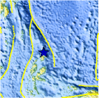
| Location | 2.724°N, 128.519°E |
| Depth | 211.2 km (131.2 miles) |
| Region | HALMAHERA, INDONESIA |
| Distances | 248 km (154 miles) NNE of Ternate, Moluccas, Indonesia 430 km (267 miles) ENE of Manado, Sulawesi, Indonesia 836 km (519 miles) SW of KOROR, Palau 1553 km (964 miles) SSE of MANILA, Philippines |
| Location Uncertainty | horizontal +/- 17.3 km (10.7 miles); depth +/- 11.9 km (7.4 miles) |
| Parameters | NST= 61, Nph= 63, Dmin=581.1 km, Rmss=1.33 sec, Gp= 90°, M-type=body wave magnitude (Mb), Version=6 |
| Source |
|
| Event ID | usc0005niy |
- Did you feel it? Report shaking and damage at your location. You can also view a map displaying accumulated data from your report and others.

Earthquake Maps


Scientific & Technical Information
 Historic Moment Tensor Solutions
 Tsunami Information
The earthquake locations and magnitudes cited in NOAA tsunami statements and bulletins are preliminary and are superseded by USGS locations and magnitudes computed using more extensive data sets.
General Tsunami Information
- Preliminary Earthquake Report
- U.S. Geological Survey, National Earthquake Information Center:
World Data Center for Seismology, Denver
