
Magnitude 4.4 - BANDA SEA
2011 September 01 23:48:07 UTC
Earthquake Details
- This event has been reviewed by a seismologist.
| Magnitude | 4.4 |
|---|---|
| Date-Time |
|
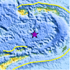
| Location | 5.975°S, 127.946°E |
| Depth | 387.1 km (240.5 miles) |
| Region | BANDA SEA |
| Distances | 252 km (156 miles) S of Ambon, Moluccas, Indonesia 388 km (241 miles) NE of DILI, Timor-Leste 431 km (267 miles) WNW of Saumlaki, Kepulauan Tanimbar, Indonesia 785 km (487 miles) NNW of DARWIN, Northern Territory, Australia |
| Location Uncertainty | horizontal +/- 18.3 km (11.4 miles); depth +/- 26.4 km (16.4 miles) |
| Parameters | NST= 12, Nph= 16, Dmin=431.9 km, Rmss=0.48 sec, Gp=101°, M-type=body wave magnitude (Mb), Version=4 |
| Source |
|
| Event ID | usc0005n51 |
- Did you feel it? Report shaking and damage at your location. You can also view a map displaying accumulated data from your report and others.

Earthquake Maps


Scientific & Technical Information
 Historic Moment Tensor Solutions
- Preliminary Earthquake Report
- U.S. Geological Survey, National Earthquake Information Center:
World Data Center for Seismology, Denver
