
Magnitude 4.6 - SOUTH OF SUMBAWA, INDONESIA
2011 September 01 03:57:57 UTC
Earthquake Details
- This event has been reviewed by a seismologist.
| Magnitude | 4.6 |
|---|---|
| Date-Time |
|
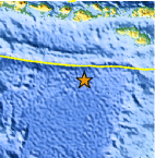
| Location | 12.079°S, 117.348°E |
| Depth | 10.2 km (6.3 miles) |
| Region | SOUTH OF SUMBAWA, INDONESIA |
| Distances | 409 km (254 miles) SSE of Mataram, Lombok, Indonesia 417 km (259 miles) SW of Waingapu, Sumba, Indonesia 981 km (609 miles) WSW of DILI, Timor-Leste 1328 km (825 miles) ESE of JAKARTA, Java, Indonesia |
| Location Uncertainty | horizontal +/- 23.2 km (14.4 miles); depth +/- 8.5 km (5.3 miles) |
| Parameters | NST= 19, Nph= 20, Dmin=531 km, Rmss=1.3 sec, Gp=137°, M-type=body wave magnitude (Mb), Version=5 |
| Source |
|
| Event ID | usc0005mq6 |
- Did you feel it? Report shaking and damage at your location. You can also view a map displaying accumulated data from your report and others.

Earthquake Maps


Scientific & Technical Information
 Historic Moment Tensor Solutions
- Preliminary Earthquake Report
- U.S. Geological Survey, National Earthquake Information Center:
World Data Center for Seismology, Denver
