
Magnitude 4.7 - SOLOMON ISLANDS
2011 May 26 04:19:42 UTC
Earthquake Details
- This event has been reviewed by a seismologist.
| Magnitude | 4.7 |
|---|---|
| Date-Time |
|
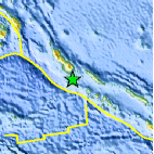
| Location | 7.155°S, 155.770°E |
| Depth | 124.8 km (77.6 miles) |
| Region | SOLOMON ISLANDS |
| Distances | 104 km (64 miles) WSW of Chirovanga, Choiseul, Solomon Islands 107 km (66 miles) SSE of Arawa, Bougainville, PNG 524 km (325 miles) WNW of HONIARA, Guadalcanal, Solomon Islands 2270 km (1410 miles) N of BRISBANE, Queensland, Australia |
| Location Uncertainty | horizontal +/- 21.7 km (13.5 miles); depth +/- 9.4 km (5.8 miles) |
| Parameters | NST= 39, Nph= 40, Dmin=516.5 km, Rmss=1.32 sec, Gp= 94°, M-type=body wave magnitude (Mb), Version=8 |
| Source |
|
| Event ID | usc0003ps8 |
- Did you feel it? Report shaking and damage at your location. You can also view a map displaying accumulated data from your report and others.
Earthquake Maps


Scientific & Technical Information
 Historic Moment Tensor Solutions
- Preliminary Earthquake Report
- U.S. Geological Survey, National Earthquake Information Center:
World Data Center for Seismology, Denver
