
Magnitude 4.6 - TONGA
2011 May 25 11:55:37 UTC
Earthquake Details
- This event has been reviewed by a seismologist.
| Magnitude | 4.6 |
|---|---|
| Date-Time |
|
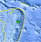
| Location | 17.211°S, 173.494°W |
| Depth | 116.4 km (72.3 miles) |
| Region | TONGA |
| Distances | 142 km (88 miles) S of Hihifo, Tonga 167 km (103 miles) NNE of Neiafu, Tonga 418 km (259 miles) SSW of APIA, Samoa 2465 km (1531 miles) NNE of Auckland, New Zealand |
| Location Uncertainty | horizontal +/- 34.5 km (21.4 miles); depth +/- 9 km (5.6 miles) |
| Parameters | NST= 81, Nph= 81, Dmin=899.5 km, Rmss=0.88 sec, Gp=137°, M-type=body wave magnitude (Mb), Version=6 |
| Source |
|
| Event ID | usc0003nuv |
- Did you feel it? Report shaking and damage at your location. You can also view a map displaying accumulated data from your report and others.
Earthquake Maps


Scientific & Technical Information
 Historic Moment Tensor Solutions
- Preliminary Earthquake Report
- U.S. Geological Survey, National Earthquake Information Center:
World Data Center for Seismology, Denver
