
Magnitude 4.9 - SOUTHERN SUMATRA, INDONESIA
2011 May 24 23:29:35 UTC
Earthquake Details
- This event has been reviewed by a seismologist.
| Magnitude | 4.9 |
|---|---|
| Date-Time |
|
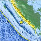
| Location | 4.343°S, 102.092°E |
| Depth | 65 km (40.4 miles) |
| Region | SOUTHERN SUMATRA, INDONESIA |
| Distances | 62 km (38 miles) SSW of Bengkulu, Sumatra, Indonesia 143 km (88 miles) SW of Lubuklinggau, Sumatra, Indonesia 258 km (160 miles) WSW of Perabumulih, Sumatra, Indonesia 563 km (349 miles) WNW of JAKARTA, Java, Indonesia |
| Location Uncertainty | horizontal +/- 20.8 km (12.9 miles); depth +/- 10.9 km (6.8 miles) |
| Parameters | NST= 40, Nph= 42, Dmin=330.6 km, Rmss=0.81 sec, Gp= 86°, M-type=body wave magnitude (Mb), Version=8 |
| Source |
|
| Event ID | usc0003ngs |
- Did you feel it? Report shaking and damage at your location. You can also view a map displaying accumulated data from your report and others.

Earthquake Maps


Scientific & Technical Information
 Historic Moment Tensor Solutions
- Preliminary Earthquake Report
- U.S. Geological Survey, National Earthquake Information Center:
World Data Center for Seismology, Denver
