
Magnitude 4.2 - KEPULAUAN BARAT DAYA, INDONESIA
2011 May 24 17:20:09 UTC
Earthquake Details
- This event has been reviewed by a seismologist.
| Magnitude | 4.2 |
|---|---|
| Date-Time |
|
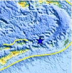
| Location | 7.480°S, 128.465°E |
| Depth | 163.1 km (101.4 miles) |
| Region | KEPULAUAN BARAT DAYA, INDONESIA |
| Distances | 318 km (197 miles) W of Saumlaki, Kepulauan Tanimbar, Indonesia 340 km (211 miles) ENE of DILI, Timor-Leste 419 km (260 miles) S of Ambon, Moluccas, Indonesia 609 km (378 miles) NNW of DARWIN, Northern Territory, Australia |
| Location Uncertainty | horizontal +/- 23.2 km (14.4 miles); depth +/- 14 km (8.7 miles) |
| Parameters | NST= 24, Nph= 24, Dmin=317.3 km, Rmss=1.22 sec, Gp= 58°, M-type=body wave magnitude (Mb), Version=7 |
| Source |
|
| Event ID | usc0003msb |
- Did you feel it? Report shaking and damage at your location. You can also view a map displaying accumulated data from your report and others.

Earthquake Maps


Scientific & Technical Information
 Historic Moment Tensor Solutions
- Preliminary Earthquake Report
- U.S. Geological Survey, National Earthquake Information Center:
World Data Center for Seismology, Denver
