
Magnitude 4.6 - SULAWESI, INDONESIA
2011 May 23 06:50:48 UTC
Earthquake Details
- This event has been reviewed by a seismologist.
| Magnitude | 4.6 |
|---|---|
| Date-Time |
|
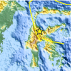
| Location | 1.526°S, 120.459°E |
| Depth | 50.3 km (31.3 miles) |
| Region | SULAWESI, INDONESIA |
| Distances | 164 km (101 miles) N of Palopo, Sulawesi, Indonesia 277 km (172 miles) SSE of Palu, Sulawesi, Indonesia 1598 km (992 miles) ENE of JAKARTA, Java, Indonesia 1665 km (1034 miles) NW of DARWIN, Northern Territory, Australia |
| Location Uncertainty | horizontal +/- 13.1 km (8.1 miles); depth +/- 15.1 km (9.4 miles) |
| Parameters | NST= 21, Nph= 21, Dmin=262.7 km, Rmss=0.61 sec, Gp= 94°, M-type=body wave magnitude (Mb), Version=8 |
| Source |
|
| Event ID | usc0003ljd |
- Did you feel it? Report shaking and damage at your location. You can also view a map displaying accumulated data from your report and others.

Earthquake Maps


Scientific & Technical Information
 Historic Moment Tensor Solutions
- Preliminary Earthquake Report
- U.S. Geological Survey, National Earthquake Information Center:
World Data Center for Seismology, Denver
