
Magnitude 5.7 - MINDORO, PHILIPPINES
2011 May 22 16:42:23 UTC
Earthquake Details
- This event has been reviewed by a seismologist.
| Magnitude | 5.7 |
|---|---|
| Date-Time |
|
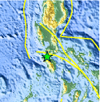
| Location | 13.669°N, 120.720°E |
| Depth | 134.8 km (83.8 miles) |
| Region | MINDORO, PHILIPPINES |
| Distances | 36 km (22 miles) WSW of Batangas, Luzon, Philippines 52 km (32 miles) WNW of Calapan, Mindoro, Philippines 112 km (69 miles) SSW of MANILA, Philippines 144 km (89 miles) SSE of Olongapo, Luzon, Philippines |
| Location Uncertainty | horizontal +/- 12.9 km (8.0 miles); depth +/- 5 km (3.1 miles) |
| Parameters | NST=387, Nph=424, Dmin=902.8 km, Rmss=1.01 sec, Gp= 32°, M-type=teleseismic moment magnitude (Mw), Version=A |
| Source |
|
| Event ID | usc0003l8x |
- Did you feel it? Report shaking and damage at your location. You can also view a map displaying accumulated data from your report and others.

Earthquake Maps


- Preliminary Earthquake Report
- U.S. Geological Survey, National Earthquake Information Center:
World Data Center for Seismology, Denver
