
Magnitude 4.6 - WESTERN AUSTRALIA
2011 May 20 20:03:28 UTC
Earthquake Details
- This event has been reviewed by a seismologist.
| Magnitude | 4.6 |
|---|---|
| Date-Time |
|
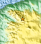
| Location | 23.540°S, 119.401°E |
| Depth | 15 km (9.3 miles) |
| Region | WESTERN AUSTRALIA |
| Distances | 42 km (26 miles) W of Newman, Western Australia, Australia 351 km (218 miles) SSE of Port Hedland, Western Aust., Australia 1005 km (624 miles) NNE of PERTH, Western Australia, Australia 3171 km (1970 miles) WNW of CANBERRA, A.C.T., Australia |
| Location Uncertainty | horizontal +/- 27.8 km (17.3 miles); depth +/- 9.8 km (6.1 miles) |
| Parameters | Nph= 0, Dmin=0 km, Rmss=1.1 sec, Gp= 0, M-type=body wave magnitude (Mb), Version=6 |
| Source |
|
| Event ID | usc0003k2s |
- Did you feel it? Report shaking and damage at your location. You can also view a map displaying accumulated data from your report and others.

Earthquake Maps


Scientific & Technical Information
- Preliminary Earthquake Report
- U.S. Geological Survey, National Earthquake Information Center:
World Data Center for Seismology, Denver
