
Magnitude 5.1 - BANDA SEA
2011 May 19 06:33:11 UTC
Earthquake Details
- This event has been reviewed by a seismologist.
| Magnitude | 5.1 |
|---|---|
| Date-Time |
|
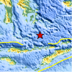
| Location | 6.965°S, 123.444°E |
| Depth | 623.7 km (387.6 miles) |
| Region | BANDA SEA |
| Distances | 189 km (117 miles) SSE of Baubau, Sulawesi, Indonesia 286 km (177 miles) NE of Ende, Flores, Indonesia 294 km (182 miles) NW of DILI, Timor-Leste 1014 km (630 miles) NW of DARWIN, Northern Territory, Australia |
| Location Uncertainty | horizontal +/- 16 km (9.9 miles); depth +/- 10.9 km (6.8 miles) |
| Parameters | NST= 65, Nph= 80, Dmin=228.2 km, Rmss=0.73 sec, Gp= 50°, M-type=body wave magnitude (Mb), Version=7 |
| Source |
|
| Event ID | usc0003iqs |
- Did you feel it? Report shaking and damage at your location. You can also view a map displaying accumulated data from your report and others.

Earthquake Maps


Scientific & Technical Information
 Historic Moment Tensor Solutions
 Tsunami Information
The earthquake locations and magnitudes cited in NOAA tsunami statements and bulletins are preliminary and are superseded by USGS locations and magnitudes computed using more extensive data sets.
General Tsunami Information
- Preliminary Earthquake Report
- U.S. Geological Survey, National Earthquake Information Center:
World Data Center for Seismology, Denver
