
Magnitude 4.5 - PHILIPPINE ISLANDS REGION
2011 May 19 03:43:04 UTC
Earthquake Details
- This event has been reviewed by a seismologist.
| Magnitude | 4.5 |
|---|---|
| Date-Time |
|
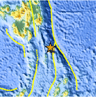
| Location | 5.077°N, 127.174°E |
| Depth | 31.2 km (19.4 miles) |
| Region | PHILIPPINE ISLANDS REGION |
| Distances | 249 km (154 miles) ESE of General Santos, Mindanao, Philippines 279 km (173 miles) SE of Davao, Mindanao, Philippines 848 km (526 miles) WSW of KOROR, Palau 1253 km (778 miles) SSE of MANILA, Philippines |
| Location Uncertainty | horizontal +/- 34.4 km (21.4 miles); depth +/- 12.9 km (8.0 miles) |
| Parameters | NST= 20, Nph= 21, Dmin=282.8 km, Rmss=1.43 sec, Gp=101°, M-type=body wave magnitude (Mb), Version=3 |
| Source |
|
| Event ID | usc0003inv |
- Did you feel it? Report shaking and damage at your location. You can also view a map displaying accumulated data from your report and others.
Earthquake Maps


Scientific & Technical Information
 Historic Moment Tensor Solutions
- Preliminary Earthquake Report
- U.S. Geological Survey, National Earthquake Information Center:
World Data Center for Seismology, Denver
