
Magnitude 5.4 - SOUTH OF TONGA
2011 May 18 21:39:42 UTC
Earthquake Details
- This event has been reviewed by a seismologist.
| Magnitude | 5.4 |
|---|---|
| Date-Time |
|
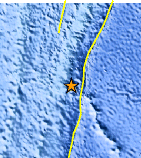
| Location | 25.372°S, 175.968°W |
| Depth | 32.7 km (20.3 miles) |
| Region | SOUTH OF TONGA |
| Distances | 472 km (293 miles) NNE of Raoul Island, Kermadec Islands 475 km (295 miles) S of NUKU`ALOFA, Tonga 592 km (367 miles) SSE of Ndoi Island, Fiji 1549 km (962 miles) NE of Auckland, New Zealand |
| Location Uncertainty | horizontal +/- 21.7 km (13.5 miles); depth +/- 6.8 km (4.2 miles) |
| Parameters | NST= 71, Nph= 72, Dmin=>999 km, Rmss=0.99 sec, Gp=101°, M-type=body wave magnitude (Mb), Version=6 |
| Source |
|
| Event ID | usc0003if7 |
- Did you feel it? Report shaking and damage at your location. You can also view a map displaying accumulated data from your report and others.
Earthquake Maps


Scientific & Technical Information
 Historic Moment Tensor Solutions
 Tsunami Information
The earthquake locations and magnitudes cited in NOAA tsunami statements and bulletins are preliminary and are superseded by USGS locations and magnitudes computed using more extensive data sets.
General Tsunami Information
- Preliminary Earthquake Report
- U.S. Geological Survey, National Earthquake Information Center:
World Data Center for Seismology, Denver
