
Magnitude 4.9 - EASTERN NEW GUINEA REG, PAPUA NEW GUINEA
2011 May 18 18:29:02 UTC
Earthquake Details
- This event has been reviewed by a seismologist.
| Magnitude | 4.9 |
|---|---|
| Date-Time |
|
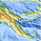
| Location | 6.661°S, 147.850°E |
| Depth | 53.8 km (33.4 miles) |
| Region | EASTERN NEW GUINEA REG, PAPUA NEW GUINEA |
| Distances |
|
| Location Uncertainty | horizontal +/- 19.4 km (12.1 miles); depth +/- 9.9 km (6.2 miles) |
| Parameters | NST= 77, Nph= 77, Dmin=312.8 km, Rmss=1 sec, Gp=112°, M-type=body wave magnitude (Mb), Version=6 |
| Source |
|
| Event ID | usc0003i52 |
- Did you feel it? Report shaking and damage at your location. You can also view a map displaying accumulated data from your report and others.

Earthquake Maps


Scientific & Technical Information
 Historic Moment Tensor Solutions
- Preliminary Earthquake Report
- U.S. Geological Survey, National Earthquake Information Center:
World Data Center for Seismology, Denver
