
Magnitude 4.9 - TONGA
2011 May 18 08:10:14 UTC
Earthquake Details
- This event has been reviewed by a seismologist.
| Magnitude | 4.9 |
|---|---|
| Date-Time |
|
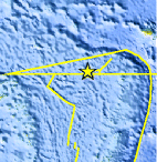
| Location | 15.592°S, 175.544°W |
| Depth | 47.9 km (29.8 miles) |
| Region | TONGA |
| Distances | 195 km (121 miles) WNW of Hihifo, Tonga 263 km (163 miles) SSE of MATA'UTU, Ile Uvea, Wallis and Futuna 316 km (196 miles) ESE of Sigave, Ile Futuna, Wallis and Futuna 2545 km (1581 miles) NNE of Auckland, New Zealand |
| Location Uncertainty | horizontal +/- 25 km (15.5 miles); depth +/- 7.3 km (4.5 miles) |
| Parameters | NST= 73, Nph= 76, Dmin=723.6 km, Rmss=1.41 sec, Gp= 65°, M-type=body wave magnitude (Mb), Version=6 |
| Source |
|
| Event ID | usc0003hwp |
- Did you feel it? Report shaking and damage at your location. You can also view a map displaying accumulated data from your report and others.
Earthquake Maps


Scientific & Technical Information
 Historic Moment Tensor Solutions
- Preliminary Earthquake Report
- U.S. Geological Survey, National Earthquake Information Center:
World Data Center for Seismology, Denver
