
Magnitude 4.5 - BANDA SEA
2011 May 17 17:47:40 UTC
Earthquake Details
- This event has been reviewed by a seismologist.
| Magnitude | 4.5 |
|---|---|
| Date-Time |
|
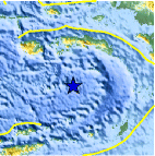
| Location | 5.417°S, 128.779°E |
| Depth | 288 km (179.0 miles) |
| Region | BANDA SEA |
| Distances | 201 km (124 miles) SSE of Ambon, Moluccas, Indonesia 396 km (246 miles) NW of Saumlaki, Kepulauan Tanimbar, Indonesia 495 km (307 miles) NE of DILI, Timor-Leste 811 km (503 miles) NNW of DARWIN, Northern Territory, Australia |
| Location Uncertainty | horizontal +/- 15.3 km (9.5 miles); depth +/- 13.5 km (8.4 miles) |
| Parameters | NST= 34, Nph= 41, Dmin=397.4 km, Rmss=0.79 sec, Gp= 68°, M-type=body wave magnitude (Mb), Version=A |
| Source |
|
| Event ID | usc0003hh3 |
- Did you feel it? Report shaking and damage at your location. You can also view a map displaying accumulated data from your report and others.

Earthquake Maps


Scientific & Technical Information
 Historic Moment Tensor Solutions
- Preliminary Earthquake Report
- U.S. Geological Survey, National Earthquake Information Center:
World Data Center for Seismology, Denver
