
Magnitude 4.8 - NEAR THE NORTH COAST OF PAPUA, INDONESIA
2011 May 16 02:35:21 UTC
Earthquake Details
- This event has been reviewed by a seismologist.
| Magnitude | 4.8 |
|---|---|
| Date-Time |
|
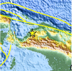
| Location | 2.758°S, 136.592°E |
| Depth | 42.5 km (26.4 miles) |
| Region | NEAR THE NORTH COAST OF PAPUA, INDONESIA |
| Distances | 131 km (81 miles) N of Enarotali, Papua, Indonesia 348 km (216 miles) SE of Manokwari, Papua, Indonesia 1247 km (774 miles) NNE of DARWIN, Northern Territory, Australia 3324 km (2065 miles) E of JAKARTA, Java, Indonesia |
| Location Uncertainty | horizontal +/- 21.8 km (13.5 miles); depth +/- 9.7 km (6.0 miles) |
| Parameters | NST= 50, Nph= 56, Dmin=483.1 km, Rmss=1.29 sec, Gp= 29°, M-type=body wave magnitude (Mb), Version=7 |
| Source |
|
| Event ID | usc0003g6d |
- Did you feel it? Report shaking and damage at your location. You can also view a map displaying accumulated data from your report and others.

Earthquake Maps


Scientific & Technical Information
 Historic Moment Tensor Solutions
- Preliminary Earthquake Report
- U.S. Geological Survey, National Earthquake Information Center:
World Data Center for Seismology, Denver
