
Magnitude 4.9 - SANTA CRUZ ISLANDS
2011 May 16 02:20:02 UTC
Earthquake Details
- This event has been reviewed by a seismologist.
| Magnitude | 4.9 |
|---|---|
| Date-Time |
|
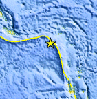
| Location | 11.556°S, 165.126°E |
| Depth | 36.6 km (22.7 miles) |
| Region | SANTA CRUZ ISLANDS |
| Distances | 120 km (74 miles) SW of Lata, Santa Cruz Islands, Solomon Isl. 371 km (230 miles) ESE of Kira Kira, San Cristobal, Solomon Isl. 613 km (380 miles) ESE of HONIARA, Guadalcanal, Solomon Islands 2171 km (1348 miles) NE of BRISBANE, Queensland, Australia |
| Location Uncertainty | horizontal +/- 29 km (18.0 miles); depth +/- 7.3 km (4.5 miles) |
| Parameters | NST= 56, Nph= 56, Dmin=>999 km, Rmss=1.3 sec, Gp=158°, M-type=body wave magnitude (Mb), Version=F |
| Source |
|
| Event ID | usc0003g66 |
- Did you feel it? Report shaking and damage at your location. You can also view a map displaying accumulated data from your report and others.
Earthquake Maps


Scientific & Technical Information
 Historic Moment Tensor Solutions
- Preliminary Earthquake Report
- U.S. Geological Survey, National Earthquake Information Center:
World Data Center for Seismology, Denver
