
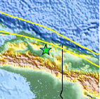
Magnitude 5.7 - PAPUA, INDONESIA
2011 May 15 06:47:04 UTC
Earthquake Details
- This event has been reviewed by a seismologist.
| Magnitude | 5.7 |
|---|---|
| Date-Time |
|
| Location | 3.061°S, 139.674°E |
| Depth | 86.8 km (53.9 miles) |
| Region | PAPUA, INDONESIA |
| Distances | 128 km (79 miles) WSW of Jayapura, Papua, Indonesia 182 km (113 miles) WSW of Vanimo, New Guinea, PNG 1425 km (885 miles) NE of DARWIN, Northern Territory, Australia 3660 km (2274 miles) E of JAKARTA, Java, Indonesia |
| Location Uncertainty | horizontal +/- 15.4 km (9.6 miles); depth +/- 10.9 km (6.8 miles) |
| Parameters | NST= 69, Nph= 70, Dmin=826 km, Rmss=0.8 sec, Gp= 32°, M-type=body wave magnitude (Mb), Version=8 |
| Source |
|
| Event ID | usc0003fmc |
- Did you feel it? Report shaking and damage at your location. You can also view a map displaying accumulated data from your report and others.

Earthquake Maps


Scientific & Technical Information

 Tsunami Information
The earthquake locations and magnitudes cited in NOAA tsunami statements and bulletins are preliminary and are superseded by USGS locations and magnitudes computed using more extensive data sets.
General Tsunami Information
- Preliminary Earthquake Report
- U.S. Geological Survey, National Earthquake Information Center:
World Data Center for Seismology, Denver
