
Magnitude 5.1 - FLORES REGION, INDONESIA
2011 May 14 01:42:15 UTC
Earthquake Details
- This event has been reviewed by a seismologist.
| Magnitude | 5.1 |
|---|---|
| Date-Time |
|
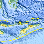
| Location | 8.118°S, 123.596°E |
| Depth | 33.5 km (20.8 miles) |
| Region | FLORES REGION, INDONESIA |
| Distances | 222 km (137 miles) WNW of DILI, Timor-Leste 226 km (140 miles) N of Kupang, Timor, Indonesia 228 km (141 miles) ENE of Ende, Flores, Indonesia 927 km (576 miles) WNW of DARWIN, Northern Territory, Australia |
| Location Uncertainty | horizontal +/- 16.6 km (10.3 miles); depth +/- 5.5 km (3.4 miles) |
| Parameters | NST= 51, Nph= 52, Dmin=160.3 km, Rmss=1.28 sec, Gp= 68°, M-type=body wave magnitude (Mb), Version=6 |
| Source |
|
| Event ID | usc0003evr |
- Did you feel it? Report shaking and damage at your location. You can also view a map displaying accumulated data from your report and others.

Earthquake Maps


Scientific & Technical Information
 Historic Moment Tensor Solutions
 Tsunami Information
The earthquake locations and magnitudes cited in NOAA tsunami statements and bulletins are preliminary and are superseded by USGS locations and magnitudes computed using more extensive data sets.
General Tsunami Information
- Preliminary Earthquake Report
- U.S. Geological Survey, National Earthquake Information Center:
World Data Center for Seismology, Denver
