
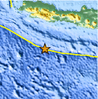
Magnitude 5.2 - SOUTH OF JAVA, INDONESIA
2011 May 13 21:43:20 UTC
Earthquake Details
- This event has been reviewed by a seismologist.
| Magnitude | 5.2 |
|---|---|
| Date-Time |
|
| Location | 9.990°S, 107.647°E |
| Depth | 12.5 km (7.8 miles) |
| Region | SOUTH OF JAVA, INDONESIA |
| Distances | 224 km (139 miles) ENE of Christmas Island 300 km (186 miles) SSW of Tasikmalaya, Java, Indonesia 340 km (211 miles) S of Bandung, Java, Indonesia 431 km (267 miles) SSE of JAKARTA, Java, Indonesia |
| Location Uncertainty | horizontal +/- 14.6 km (9.1 miles); depth +/- 6.3 km (3.9 miles) |
| Parameters | NST= 90, Nph= 93, Dmin=224.9 km, Rmss=0.65 sec, Gp= 40°, M-type=body wave magnitude (Mb), Version=8 |
| Source |
|
| Event ID | usc0003er2 |
- Did you feel it? Report shaking and damage at your location. You can also view a map displaying accumulated data from your report and others.

Earthquake Maps


Scientific & Technical Information
 Historic Moment Tensor Solutions
 Tsunami Information
The earthquake locations and magnitudes cited in NOAA tsunami statements and bulletins are preliminary and are superseded by USGS locations and magnitudes computed using more extensive data sets.
General Tsunami Information
- Preliminary Earthquake Report
- U.S. Geological Survey, National Earthquake Information Center:
World Data Center for Seismology, Denver
