
Magnitude 4.8 - FIJI REGION
2011 May 13 17:05:06 UTC
Earthquake Details
- This event has been reviewed by a seismologist.
| Magnitude | 4.8 |
|---|---|
| Date-Time |
|
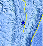
| Location | 20.985°S, 176.647°W |
| Depth | 215.4 km (133.8 miles) |
| Region | FIJI REGION |
| Distances | 145 km (90 miles) W of NUKU`ALOFA, Tonga 223 km (138 miles) ESE of Ndoi Island, Fiji 384 km (238 miles) SW of Neiafu, Tonga 1938 km (1204 miles) NNE of Auckland, New Zealand |
| Location Uncertainty | horizontal +/- 21 km (13.0 miles); depth +/- 7.9 km (4.9 miles) |
| Parameters | NST=166, Nph=166, Dmin=662.4 km, Rmss=0.84 sec, Gp=119°, M-type=body wave magnitude (Mb), Version=D |
| Source |
|
| Event ID | usc0003e82 |
- Did you feel it? Report shaking and damage at your location. You can also view a map displaying accumulated data from your report and others.
Earthquake Maps


Scientific & Technical Information
 Historic Moment Tensor Solutions
- Preliminary Earthquake Report
- U.S. Geological Survey, National Earthquake Information Center:
World Data Center for Seismology, Denver
