
Magnitude 4.5 - EASTERN NEW GUINEA REG, PAPUA NEW GUINEA
2011 May 13 07:43:17 UTC
Earthquake Details
- This event has been reviewed by a seismologist.
| Magnitude | 4.5 |
|---|---|
| Date-Time |
|
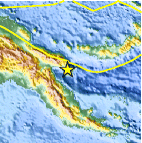
| Location | 6.899°S, 147.820°E |
| Depth | 66.4 km (41.3 miles) |
| Region | EASTERN NEW GUINEA REG, PAPUA NEW GUINEA |
| Distances | 92 km (57 miles) ESE of Lae, New Guinea, PNG 205 km (127 miles) WSW of Kandrian, New Britain, PNG 291 km (180 miles) NNE of PORT MORESBY, Papua New Guinea 2345 km (1457 miles) NNW of BRISBANE, Queensland, Australia |
| Location Uncertainty | horizontal +/- 26 km (16.2 miles); depth +/- 9.2 km (5.7 miles) |
| Parameters | NST= 20, Nph= 20, Dmin=286.1 km, Rmss=0.72 sec, Gp=137°, M-type=body wave magnitude (Mb), Version=5 |
| Source |
|
| Event ID | usc0003dwi |
- Did you feel it? Report shaking and damage at your location. You can also view a map displaying accumulated data from your report and others.

Earthquake Maps


Scientific & Technical Information
 Historic Moment Tensor Solutions
- Preliminary Earthquake Report
- U.S. Geological Survey, National Earthquake Information Center:
World Data Center for Seismology, Denver
