
Magnitude 4.7 - MINAHASA, SULAWESI, INDONESIA
2011 May 13 05:11:56 UTC
Earthquake Details
- This event has been reviewed by a seismologist.
| Magnitude | 4.7 |
|---|---|
| Date-Time |
|
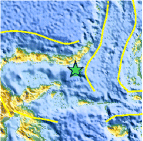
| Location | 0.043°N, 124.213°E |
| Depth | 98.6 km (61.3 miles) |
| Region | MINAHASA, SULAWESI, INDONESIA |
| Distances | 139 km (86 miles) ESE of Gorontalo, Sulawesi, Indonesia 176 km (109 miles) SSW of Manado, Sulawesi, Indonesia 962 km (597 miles) N of DILI, Timor-Leste 1649 km (1024 miles) SSE of MANILA, Philippines |
| Location Uncertainty | horizontal +/- 18.6 km (11.6 miles); depth +/- 3.7 km (2.3 miles) |
| Parameters | NST= 61, Nph= 62, Dmin=200.4 km, Rmss=1.17 sec, Gp= 54°, M-type=body wave magnitude (Mb), Version=6 |
| Source |
|
| Event ID | usc0003dt7 |
- Did you feel it? Report shaking and damage at your location. You can also view a map displaying accumulated data from your report and others.

Earthquake Maps


Scientific & Technical Information
 Historic Moment Tensor Solutions
- Preliminary Earthquake Report
- U.S. Geological Survey, National Earthquake Information Center:
World Data Center for Seismology, Denver
