
Magnitude 4.6 - NORTHERN SUMATRA, INDONESIA
2011 May 12 08:32:43 UTC
Earthquake Details
- This event has been reviewed by a seismologist.
| Magnitude | 4.6 |
|---|---|
| Date-Time |
|
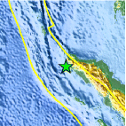
| Location | 4.784°N, 95.201°E |
| Depth | 72.4 km (45.0 miles) |
| Region | NORTHERN SUMATRA, INDONESIA |
| Distances | 87 km (54 miles) S of Banda Aceh, Sumatra, Indonesia 220 km (136 miles) WSW of Lhokseumawe, Sumatra, Indonesia 743 km (461 miles) WNW of KUALA LUMPUR, Malaysia 1771 km (1100 miles) NW of JAKARTA, Java, Indonesia |
| Location Uncertainty | horizontal +/- 30.4 km (18.9 miles); depth +/- 12.7 km (7.9 miles) |
| Parameters | NST= 21, Nph= 21, Dmin=199.3 km, Rmss=0.54 sec, Gp=173°, M-type=body wave magnitude (Mb), Version=4 |
| Source |
|
| Event ID | usc0003cpl |
- Did you feel it? Report shaking and damage at your location. You can also view a map displaying accumulated data from your report and others.

Earthquake Maps


Scientific & Technical Information
 Historic Moment Tensor Solutions
- Preliminary Earthquake Report
- U.S. Geological Survey, National Earthquake Information Center:
World Data Center for Seismology, Denver
