
Magnitude 4.7 - OFF THE WEST COAST OF NORTHERN SUMATRA
2011 May 12 08:04:31 UTC
Earthquake Details
- This event has been reviewed by a seismologist.
| Magnitude | 4.7 |
|---|---|
| Date-Time |
|
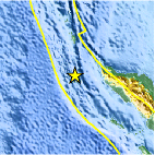
| Location | 5.094°N, 93.876°E |
| Depth | 51.3 km (31.9 miles) |
| Region | OFF THE WEST COAST OF NORTHERN SUMATRA |
| Distances | 168 km (104 miles) WSW of Banda Aceh, Sumatra, Indonesia 324 km (201 miles) S of Mohean, Nicobar Islands, India 893 km (554 miles) WNW of KUALA LUMPUR, Malaysia 1903 km (1182 miles) NW of JAKARTA, Java, Indonesia |
| Location Uncertainty | horizontal +/- 39.3 km (24.4 miles); depth +/- 16.7 km (10.4 miles) |
| Parameters | NST= 28, Nph= 28, Dmin=340.6 km, Rmss=1.4 sec, Gp=144°, M-type=body wave magnitude (Mb), Version=5 |
| Source |
|
| Event ID | usc0003cnz |
- Did you feel it? Report shaking and damage at your location. You can also view a map displaying accumulated data from your report and others.
Earthquake Maps


Scientific & Technical Information
 Historic Moment Tensor Solutions
- Preliminary Earthquake Report
- U.S. Geological Survey, National Earthquake Information Center:
World Data Center for Seismology, Denver
