
Magnitude 4.8 - SOLOMON ISLANDS
2011 May 12 04:44:47 UTC
Earthquake Details
- This event has been reviewed by a seismologist.
| Magnitude | 4.8 |
|---|---|
| Date-Time |
|
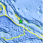
| Location | 7.006°S, 155.884°E |
| Depth | 80.6 km (50.1 miles) |
| Region | SOLOMON ISLANDS |
| Distances | 85 km (52 miles) WSW of Chirovanga, Choiseul, Solomon Islands 94 km (58 miles) SSE of Arawa, Bougainville, PNG 522 km (324 miles) WNW of HONIARA, Guadalcanal, Solomon Islands 2288 km (1421 miles) N of BRISBANE, Queensland, Australia |
| Location Uncertainty | horizontal +/- 18.8 km (11.7 miles); depth +/- 2.8 km (1.7 miles) |
| Parameters | NST= 62, Nph= 64, Dmin=516.5 km, Rmss=0.89 sec, Gp= 65°, M-type=body wave magnitude (Mb), Version=6 |
| Source |
|
| Event ID | usc0003clt |
- Did you feel it? Report shaking and damage at your location. You can also view a map displaying accumulated data from your report and others.
Earthquake Maps


Scientific & Technical Information
 Historic Moment Tensor Solutions
- Preliminary Earthquake Report
- U.S. Geological Survey, National Earthquake Information Center:
World Data Center for Seismology, Denver
