
Magnitude 4.7 - SAMOA ISLANDS REGION
2011 May 11 01:07:33 UTC
Earthquake Details
- This event has been reviewed by a seismologist.
| Magnitude | 4.7 |
|---|---|
| Date-Time |
|
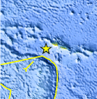
| Location | 14.004°S, 173.241°W |
| Depth | 44.8 km (27.8 miles) |
| Region | SAMOA ISLANDS REGION |
| Distances | 163 km (101 miles) W of APIA, Samoa 222 km (137 miles) NNE of Hihifo, Tonga 275 km (170 miles) W of PAGO PAGO, American Samoa 2800 km (1739 miles) NNE of Auckland, New Zealand |
| Location Uncertainty | horizontal +/- 26.6 km (16.5 miles); depth +/- 9 km (5.6 miles) |
| Parameters | NST=104, Nph=122, Dmin=158.1 km, Rmss=0.8 sec, Gp= 97°, M-type=body wave magnitude (Mb), Version=E |
| Source |
|
| Event ID | usc0003bl4 |
- Did you feel it? Report shaking and damage at your location. You can also view a map displaying accumulated data from your report and others.
Earthquake Maps


Scientific & Technical Information
 Historic Moment Tensor Solutions
- Preliminary Earthquake Report
- U.S. Geological Survey, National Earthquake Information Center:
World Data Center for Seismology, Denver
