
Magnitude 4.9 - FIJI REGION
2011 May 11 00:48:10 UTC
Earthquake Details
- This event has been reviewed by a seismologist.
| Magnitude | 4.9 |
|---|---|
| Date-Time |
|
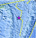
| Location | 18.826°S, 176.795°W |
| Depth | 360.9 km (224.3 miles) |
| Region | FIJI REGION |
| Distances | 283 km (175 miles) NE of Ndoi Island, Fiji 297 km (184 miles) W of Neiafu, Tonga 305 km (189 miles) NNW of NUKU`ALOFA, Tonga 2162 km (1343 miles) NNE of Auckland, New Zealand |
| Location Uncertainty | horizontal +/- 18.7 km (11.6 miles); depth +/- 10.7 km (6.6 miles) |
| Parameters | NST=204, Nph=207, Dmin=557.7 km, Rmss=0.65 sec, Gp= 94°, M-type=body wave magnitude (Mb), Version=7 |
| Source |
|
| Event ID | usc0003bkj |
- Did you feel it? Report shaking and damage at your location. You can also view a map displaying accumulated data from your report and others.
Earthquake Maps


Scientific & Technical Information
 Historic Moment Tensor Solutions
- Preliminary Earthquake Report
- U.S. Geological Survey, National Earthquake Information Center:
World Data Center for Seismology, Denver
