
Magnitude 4.9 - LOYALTY ISLANDS
2011 May 10 10:14:24 UTC
Earthquake Details
- This event has been reviewed by a seismologist.
| Magnitude | 4.9 |
|---|---|
| Date-Time |
|
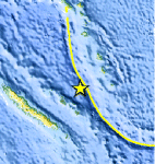
| Location | 20.387°S, 168.138°E |
| Depth | 35.3 km (21.9 miles) |
| Region | LOYALTY ISLANDS |
| Distances | 131 km (81 miles) NNE of Tadine, Loyalty Islands, New Caledonia 150 km (93 miles) SW of Isangel, Tanna, Vanuatu 271 km (168 miles) NE of NOUMEA, New Caledonia 1727 km (1073 miles) ENE of BRISBANE, Queensland, Australia |
| Location Uncertainty | horizontal +/- 25.1 km (15.6 miles); depth +/- 4.6 km (2.9 miles) |
| Parameters | NST= 30, Nph= 30, Dmin=>999 km, Rmss=1.79 sec, Gp= 83°, M-type=body wave magnitude (Mb), Version=4 |
| Source |
|
| Event ID | usc0003ajm |
- Did you feel it? Report shaking and damage at your location. You can also view a map displaying accumulated data from your report and others.
Earthquake Maps


Scientific & Technical Information
 Historic Moment Tensor Solutions
- Preliminary Earthquake Report
- U.S. Geological Survey, National Earthquake Information Center:
World Data Center for Seismology, Denver
