
Magnitude 4.6 - MINAHASA, SULAWESI, INDONESIA
2011 May 08 01:48:07 UTC
Earthquake Details
- This event has been reviewed by a seismologist.
| Magnitude | 4.6 |
|---|---|
| Date-Time |
|
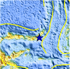
| Location | 0.632°N, 124.490°E |
| Depth | 173.1 km (107.6 miles) |
| Region | MINAHASA, SULAWESI, INDONESIA |
| Distances | 104 km (64 miles) SSW of Manado, Sulawesi, Indonesia 159 km (98 miles) E of Gorontalo, Sulawesi, Indonesia 1593 km (989 miles) SSE of MANILA, Philippines 2102 km (1306 miles) ENE of JAKARTA, Java, Indonesia |
| Location Uncertainty | horizontal +/- 15.9 km (9.9 miles); depth +/- 10.4 km (6.5 miles) |
| Parameters | NST= 57, Nph= 57, Dmin=266.1 km, Rmss=0.46 sec, Gp= 32°, M-type=body wave magnitude (Mb), Version=5 |
| Source |
|
| Event ID | usc00038r6 |
- Did you feel it? Report shaking and damage at your location. You can also view a map displaying accumulated data from your report and others.

Earthquake Maps


Scientific & Technical Information
 Historic Moment Tensor Solutions
- Preliminary Earthquake Report
- U.S. Geological Survey, National Earthquake Information Center:
World Data Center for Seismology, Denver
