
Magnitude 4.7 - SOUTH OF THE FIJI ISLANDS
2011 May 07 08:49:27 UTC
Earthquake Details
- This event has been reviewed by a seismologist.
| Magnitude | 4.7 |
|---|---|
| Date-Time |
|
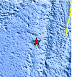
| Location | 23.424°S, 179.900°W |
| Depth | 549.3 km (341.3 miles) |
| Region | SOUTH OF THE FIJI ISLANDS |
| Distances | 330 km (205 miles) SSW of Ndoi Island, Fiji 546 km (339 miles) WSW of NUKU`ALOFA, Tonga 596 km (370 miles) ESE of Ceva-i-Ra, Fiji 1576 km (979 miles) NNE of Auckland, New Zealand |
| Location Uncertainty | horizontal +/- 22.8 km (14.2 miles); depth +/- 7.8 km (4.8 miles) |
| Parameters | NST= 69, Nph= 69, Dmin=664.6 km, Rmss=0.86 sec, Gp= 76°, M-type=body wave magnitude (Mb), Version=5 |
| Source |
|
| Event ID | usc000387q |
- Did you feel it? Report shaking and damage at your location. You can also view a map displaying accumulated data from your report and others.
Earthquake Maps


Scientific & Technical Information
 Historic Moment Tensor Solutions
- Preliminary Earthquake Report
- U.S. Geological Survey, National Earthquake Information Center:
World Data Center for Seismology, Denver
