
Magnitude 4.9 - FIJI REGION
2011 May 06 20:26:35 UTC
Earthquake Details
- This event has been reviewed by a seismologist.
| Magnitude | 4.9 |
|---|---|
| Date-Time |
|
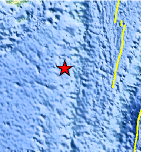
| Location | 21.668°S, 179.353°W |
| Depth | 593.9 km (369.0 miles) |
| Region | FIJI REGION |
| Distances | 131 km (81 miles) SSW of Ndoi Island, Fiji 434 km (269 miles) W of NUKU`ALOFA, Tonga 456 km (283 miles) SSE of SUVA, Viti Levu, Fiji 1778 km (1104 miles) NNE of Auckland, New Zealand |
| Location Uncertainty | horizontal +/- 23.6 km (14.7 miles); depth +/- 10.6 km (6.6 miles) |
| Parameters | NST= 49, Nph= 51, Dmin=512.1 km, Rmss=1.13 sec, Gp=126°, M-type=body wave magnitude (Mb), Version=4 |
| Source |
|
| Event ID | usc00037ut |
- Did you feel it? Report shaking and damage at your location. You can also view a map displaying accumulated data from your report and others.
Earthquake Maps


Scientific & Technical Information
 Historic Moment Tensor Solutions
- Preliminary Earthquake Report
- U.S. Geological Survey, National Earthquake Information Center:
World Data Center for Seismology, Denver
