
Magnitude 4.6 - NEAR THE NORTH COAST OF PAPUA, INDONESIA
2011 May 06 04:10:14 UTC
Earthquake Details
- This event has been reviewed by a seismologist.
| Magnitude | 4.6 |
|---|---|
| Date-Time |
|
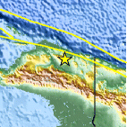
| Location | 2.765°S, 139.090°E |
| Depth | 36.2 km (22.5 miles) |
| Region | NEAR THE NORTH COAST OF PAPUA, INDONESIA |
| Distances | 180 km (111 miles) W of Jayapura, Papua, Indonesia 242 km (150 miles) W of Vanimo, New Guinea, PNG 1407 km (874 miles) NE of DARWIN, Northern Territory, Australia 3599 km (2236 miles) E of JAKARTA, Java, Indonesia |
| Location Uncertainty | horizontal +/- 22.5 km (14.0 miles); depth +/- 11.9 km (7.4 miles) |
| Parameters | NST= 20, Nph= 21, Dmin=760.3 km, Rmss=1.1 sec, Gp=104°, M-type=body wave magnitude (Mb), Version=5 |
| Source |
|
| Event ID | usc000375j |
- Did you feel it? Report shaking and damage at your location. You can also view a map displaying accumulated data from your report and others.

Earthquake Maps


Scientific & Technical Information
 Historic Moment Tensor Solutions
- Preliminary Earthquake Report
- U.S. Geological Survey, National Earthquake Information Center:
World Data Center for Seismology, Denver
