
Magnitude 4.5 - NORTH ISLAND OF NEW ZEALAND
2011 May 06 03:59:30 UTC
Earthquake Details
- This event has been reviewed by a seismologist.
| Magnitude | 4.5 |
|---|---|
| Date-Time |
|
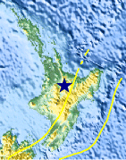
| Location | 38.422°S, 176.059°E |
| Depth | 163.3 km (101.5 miles) |
| Region | NORTH ISLAND OF NEW ZEALAND |
| Distances | 34 km (21 miles) SSW of Rotorua, New Zealand 139 km (86 miles) NNW of Napier, New Zealand 207 km (128 miles) SSE of Auckland, New Zealand 338 km (210 miles) NNE of WELLINGTON, New Zealand |
| Location Uncertainty | horizontal +/- 18.2 km (11.3 miles); depth +/- 13.2 km (8.2 miles) |
| Parameters | NST= 27, Nph= 32, Dmin=91.3 km, Rmss=1.25 sec, Gp= 97°, M-type=body wave magnitude (Mb), Version=9 |
| Source |
|
| Event ID | usc000375d |
- Did you feel it? Report shaking and damage at your location. You can also view a map displaying accumulated data from your report and others.

Earthquake Maps


Scientific & Technical Information
 Historic Moment Tensor Solutions
Additional Information
- Preliminary Earthquake Report
- U.S. Geological Survey, National Earthquake Information Center:
World Data Center for Seismology, Denver
