
Magnitude 4.6 - MINDANAO, PHILIPPINES
2011 May 05 03:46:37 UTC
Earthquake Details
- This event has been reviewed by a seismologist.
| Magnitude | 4.6 |
|---|---|
| Date-Time |
|
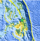
| Location | 9.126°N, 125.371°E |
| Depth | 88.5 km (55.0 miles) |
| Region | MINDANAO, PHILIPPINES |
| Distances | 27 km (16 miles) NW of Butuan, Mindanao, Philippines 73 km (45 miles) S of Surigao, Mindanao, Philippines 107 km (66 miles) NE of Cagayan de Oro, Mindanao, Philippines 771 km (479 miles) SE of MANILA, Philippines |
| Location Uncertainty | horizontal +/- 17.1 km (10.6 miles); depth +/- 8.7 km (5.4 miles) |
| Parameters | NST= 42, Nph= 42, Dmin=228.2 km, Rmss=1 sec, Gp=108°, M-type=body wave magnitude (Mb), Version=7 |
| Source |
|
| Event ID | usc00035ta |
- Did you feel it? Report shaking and damage at your location. You can also view a map displaying accumulated data from your report and others.

Earthquake Maps


Scientific & Technical Information
 Historic Moment Tensor Solutions
- Preliminary Earthquake Report
- U.S. Geological Survey, National Earthquake Information Center:
World Data Center for Seismology, Denver
