
Magnitude 4.7 - KERMADEC ISLANDS REGION
2011 May 04 22:38:59 UTC
Earthquake Details
- This event has been reviewed by a seismologist.
| Magnitude | 4.7 |
|---|---|
| Date-Time |
|
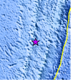
| Location | 27.298°S, 178.989°W |
| Depth | 333.2 km (207.1 miles) |
| Region | KERMADEC ISLANDS REGION |
| Distances | 242 km (150 miles) NNW of Raoul Island, Kermadec Islands 458 km (284 miles) N of L'Esperance Rock, Kermadec Islands 783 km (486 miles) SSW of NUKU`ALOFA, Tonga 1213 km (753 miles) NNE of Auckland, New Zealand |
| Location Uncertainty | horizontal +/- 19.3 km (12.0 miles); depth +/- 5.4 km (3.4 miles) |
| Parameters | NST= 70, Nph= 74, Dmin=239.3 km, Rmss=0.74 sec, Gp= 90°, M-type=body wave magnitude (Mb), Version=5 |
| Source |
|
| Event ID | usc00035qc |
- Did you feel it? Report shaking and damage at your location. You can also view a map displaying accumulated data from your report and others.
Earthquake Maps


Scientific & Technical Information
 Historic Moment Tensor Solutions
- Preliminary Earthquake Report
- U.S. Geological Survey, National Earthquake Information Center:
World Data Center for Seismology, Denver
