
Magnitude 4.7 - SOUTHERN SUMATRA, INDONESIA
2011 May 02 23:25:37 UTC
Earthquake Details
- This event has been reviewed by a seismologist.
| Magnitude | 4.7 |
|---|---|
| Date-Time |
|
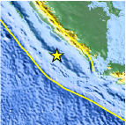
| Location | 5.556°S, 102.601°E |
| Depth | 37.3 km (23.2 miles) |
| Region | SOUTHERN SUMATRA, INDONESIA |
| Distances | 198 km (123 miles) S of Bengkulu, Sumatra, Indonesia 252 km (156 miles) S of Lubuklinggau, Sumatra, Indonesia 295 km (183 miles) W of T.-Telukbetung, Sumatra, Indonesia 473 km (293 miles) W of JAKARTA, Java, Indonesia |
| Location Uncertainty | horizontal +/- 21.4 km (13.3 miles); depth +/- 10.7 km (6.6 miles) |
| Parameters | NST= 43, Nph= 45, Dmin=138 km, Rmss=1.06 sec, Gp=184°, M-type=body wave magnitude (Mb), Version=5 |
| Source |
|
| Event ID | usc0003497 |
- Did you feel it? Report shaking and damage at your location. You can also view a map displaying accumulated data from your report and others.

Earthquake Maps


Scientific & Technical Information
 Historic Moment Tensor Solutions
- Preliminary Earthquake Report
- U.S. Geological Survey, National Earthquake Information Center:
World Data Center for Seismology, Denver
