
Magnitude 4.2 - SULAWESI, INDONESIA
2011 May 02 02:39:46 UTC
Earthquake Details
- This event has been reviewed by a seismologist.
| Magnitude | 4.2 |
|---|---|
| Date-Time |
|
| Location | 4.631°S, 122.790°E |
| Depth | 4.7 km (2.9 miles) (poorly constrained) |
| Region | SULAWESI, INDONESIA |
| Distances | 78 km (48 miles) SSE of Kendari, Sulawesi, Indonesia 94 km (58 miles) NNE of Baubau, Sulawesi, Indonesia 532 km (330 miles) NW of DILI, Timor-Leste 1239 km (769 miles) NW of DARWIN, Northern Territory, Australia |
| Location Uncertainty | horizontal +/- 19.5 km (12.1 miles); depth +/- 12.4 km (7.7 miles) |
| Parameters | NST= 12, Nph= 14, Dmin=339.5 km, Rmss=1.12 sec, Gp= 79°, M-type=body wave magnitude (Mb), Version=5 |
| Source |
|
| Event ID | usc00033hy |
- Did you feel it? Report shaking and damage at your location. You can also view a map displaying accumulated data from your report and others.
Earthquake Maps

Earthquake Location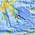
Location Maps
Historical Seismicity
Seismic Hazard Map
EQ Density Map
Google Map
Google Earth KML
(Requires Google Earth)- Did you feel it? Report shaking and damage at your location. You can also view a map displaying accumulated data from your report and others.
Scientific & Technical Information
 Historic Moment Tensor Solutions
- Preliminary Earthquake Report
- U.S. Geological Survey, National Earthquake Information Center:
World Data Center for Seismology, Denver
