
Magnitude 5.2 - SOUTH ISLAND OF NEW ZEALAND
2011 April 16 05:49:22 UTC
Earthquake Details
- This event has been reviewed by a seismologist.
| Magnitude | 5.2 |
|---|---|
| Date-Time |
|
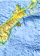
| Location | 43.626°S, 172.837°E |
| Depth | 9.2 km (5.7 miles) |
| Region | SOUTH ISLAND OF NEW ZEALAND |
| Distances | 16 km (9 miles) ESE of Christchurch, New Zealand 232 km (144 miles) SSE of Westport, New Zealand 304 km (188 miles) SSW of WELLINGTON, New Zealand 310 km (192 miles) NE of Dunedin, New Zealand |
| Location Uncertainty | horizontal +/- 11.8 km (7.3 miles); depth +/- 4.4 km (2.7 miles) |
| Parameters | NST= 42, Nph= 46, Dmin=17.8 km, Rmss=0.98 sec, Gp=184°, M-type=body wave magnitude (Mb), Version=4 |
| Source |
|
| Event ID | usc0002su1 |
- Did you feel it? Report shaking and damage at your location. You can also view a map displaying accumulated data from your report and others.

Earthquake Maps


Scientific & Technical Information

- Preliminary Earthquake Report
- U.S. Geological Survey, National Earthquake Information Center:
World Data Center for Seismology, Denver
