
Magnitude 4.7 - SOUTH OF BALI, INDONESIA
2011 April 15 11:59:09 UTC
Earthquake Details
- This event has been reviewed by a seismologist.
| Magnitude | 4.7 |
|---|---|
| Date-Time |
|
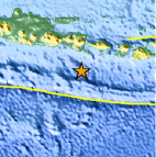
| Location | 9.684°S, 114.166°E |
| Depth | 25.5 km (15.8 miles) |
| Region | SOUTH OF BALI, INDONESIA |
| Distances | 161 km (100 miles) SW of Denpasar, Bali, Indonesia 175 km (108 miles) SSE of Jember, Java, Indonesia 237 km (147 miles) SSE of Probolinggo, Java, Indonesia 897 km (557 miles) ESE of JAKARTA, Java, Indonesia |
| Location Uncertainty | horizontal +/- 20.8 km (12.9 miles); depth +/- 8.6 km (5.3 miles) |
| Parameters | NST= 36, Nph= 39, Dmin=134.7 km, Rmss=1.81 sec, Gp= 79°, M-type=body wave magnitude (Mb), Version=7 |
| Source |
|
| Event ID | usc0002s1i |
- Did you feel it? Report shaking and damage at your location. You can also view a map displaying accumulated data from your report and others.

Earthquake Maps


Scientific & Technical Information
 Historic Moment Tensor Solutions
- Preliminary Earthquake Report
- U.S. Geological Survey, National Earthquake Information Center:
World Data Center for Seismology, Denver
