
Magnitude 5.5 - OFF EAST COAST OF THE NORTH ISLAND, N.Z.
2011 January 13 12:04:56 UTC
Earthquake Details
- This event has been reviewed by a seismologist.
| Magnitude | 5.5 |
|---|---|
| Date-Time |
|
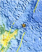
| Location | 37.004°S, 179.453°E |
| Depth | 31.4 km (19.5 miles) |
| Region | OFF EAST COAST OF THE NORTH ISLAND, N.Z. |
| Distances | 225 km (140 miles) NE of Gisborne, New Zealand 310 km (195 miles) ENE of Rotorua, New Zealand 420 km (260 miles) E of Auckland, New Zealand 625 km (390 miles) NE of WELLINGTON, New Zealand |
| Location Uncertainty | horizontal +/- 17.9 km (11.1 miles); depth +/- 0.3 km (0.2 miles) |
| Parameters | NST=114, Nph=119, Dmin=119.1 km, Rmss=1.75 sec, Gp= 65°, M-type="moment" magnitude from initial P wave (tsuboi method) (Mi/Mwp), Version=A |
| Source |
|
| Event ID | usc00012au |
- Did you feel it? Report shaking and damage at your location. You can also view a map displaying accumulated data from your report and others.

Earthquake Maps


Scientific & Technical Information

- Preliminary Earthquake Report
- U.S. Geological Survey, National Earthquake Information Center:
World Data Center for Seismology, Denver
