
Magnitude 4.6 - MINDANAO, PHILIPPINES
2011 January 12 16:42:40 UTC
Earthquake Details
- This event has been reviewed by a seismologist.
| Magnitude | 4.6 |
|---|---|
| Date-Time |
|
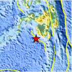
| Location | 5.685°N, 124.008°E |
| Depth | 530.9 km (329.9 miles) |
| Region | MINDANAO, PHILIPPINES |
| Distances | 135 km (85 miles) WSW of General Santos, Mindanao, Philippines 170 km (105 miles) S of Cotabato, Mindanao, Philippines 1035 km (650 miles) SSE of MANILA, Philippines 2310 km (1440 miles) NE of JAKARTA, Java, Indonesia |
| Location Uncertainty | horizontal +/- 12.1 km (7.5 miles); depth +/- 7.8 km (4.8 miles) |
| Parameters | NST= 20, Nph= 20, Dmin=231.7 km, Rmss=0.75 sec, Gp= 86°, M-type=body wave magnitude (Mb), Version=3 |
| Source |
|
| Event ID | usc00011vm |
- Did you feel it? Report shaking and damage at your location. You can also view a map displaying accumulated data from your report and others.

Earthquake Maps


Scientific & Technical Information
 Historic Moment Tensor Solutions
- Preliminary Earthquake Report
- U.S. Geological Survey, National Earthquake Information Center:
World Data Center for Seismology, Denver
