
Magnitude 4.8 - FIJI REGION
2011 January 12 14:41:11 UTC
Earthquake Details
- This event has been reviewed by a seismologist.
| Magnitude | 4.8 |
|---|---|
| Date-Time |
|
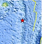
| Location | 20.783°S, 178.701°W |
| Depth | 574.8 km (357.2 miles) |
| Region | FIJI REGION |
| Distances | 15 km (10 miles) S of Ndoi Island, Fiji 365 km (225 miles) W of NUKU`ALOFA, Tonga 420 km (260 miles) SE of SUVA, Viti Levu, Fiji 1890 km (1170 miles) NNE of Auckland, New Zealand |
| Location Uncertainty | horizontal +/- 13.7 km (8.5 miles); depth +/- 20 km (12.4 miles) |
| Parameters | NST= 54, Nph= 54, Dmin=>999 km, Rmss=1.02 sec, Gp=137°, M-type=body wave magnitude (Mb), Version=5 |
| Source |
|
| Event ID | usc00011uv |
- Did you feel it? Report shaking and damage at your location. You can also view a map displaying accumulated data from your report and others.
Earthquake Maps


Scientific & Technical Information
 Historic Moment Tensor Solutions
- Preliminary Earthquake Report
- U.S. Geological Survey, National Earthquake Information Center:
World Data Center for Seismology, Denver
