
Magnitude 4.8 - TONGA
2011 January 10 10:21:44 UTC
Earthquake Details
- This event has been reviewed by a seismologist.
| Magnitude | 4.8 |
|---|---|
| Date-Time |
|
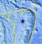
| Location | 16.927°S, 174.705°W |
| Depth | 230 km (142.9 miles) |
| Region | TONGA |
| Distances | 150 km (90 miles) SW of Hihifo, Tonga 205 km (125 miles) NNW of Neiafu, Tonga 470 km (290 miles) N of NUKU`ALOFA, Tonga 2445 km (1510 miles) NNE of Auckland, New Zealand |
| Location Uncertainty | horizontal +/- 41.3 km (25.7 miles); depth +/- 2.9 km (1.8 miles) |
| Parameters | NST= 45, Nph= 45, Dmin=458.6 km, Rmss=0.72 sec, Gp=140°, M-type=body wave magnitude (Mb), Version=6 |
| Source |
|
| Event ID | usc000119u |
- Did you feel it? Report shaking and damage at your location. You can also view a map displaying accumulated data from your report and others.
Earthquake Maps


Scientific & Technical Information
 Historic Moment Tensor Solutions
- Preliminary Earthquake Report
- U.S. Geological Survey, National Earthquake Information Center:
World Data Center for Seismology, Denver
