
Magnitude 5.3 - FIJI REGION
2011 January 10 02:11:04 UTC
Earthquake Details
- This event has been reviewed by a seismologist.
| Magnitude | 5.3 |
|---|---|
| Date-Time |
|
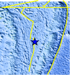
| Location | 19.467°S, 176.025°W |
| Depth | 175.9 km (109.3 miles) |
| Region | FIJI REGION |
| Distances | 205 km (125 miles) NNW of NUKU`ALOFA, Tonga 235 km (145 miles) WSW of Neiafu, Tonga 310 km (190 miles) ENE of Ndoi Island, Fiji 2130 km (1320 miles) NNE of Auckland, New Zealand |
| Location Uncertainty | horizontal +/- 20.7 km (12.9 miles); depth +/- 2.2 km (1.4 miles) |
| Parameters | NST=203, Nph=215, Dmin=763.7 km, Rmss=0.83 sec, Gp= 86°, M-type=body wave magnitude (Mb), Version=5 |
| Source |
|
| Event ID | usc0001164 |
- Did you feel it? Report shaking and damage at your location. You can also view a map displaying accumulated data from your report and others.
Earthquake Maps


Scientific & Technical Information
 Historic Moment Tensor Solutions
 Tsunami Information
The earthquake locations and magnitudes cited in NOAA tsunami statements and bulletins are preliminary and are superseded by USGS locations and magnitudes computed using more extensive data sets.
NOAA Tsunami Bulletins for this Earthquake
No Bulletins have been issued at this time.
General Tsunami Information
- Preliminary Earthquake Report
- U.S. Geological Survey, National Earthquake Information Center:
World Data Center for Seismology, Denver
