
Magnitude 4.8 - PHILIPPINE ISLANDS REGION
2011 January 08 18:30:16 UTC
Earthquake Details
- This event has been reviewed by a seismologist.
| Magnitude | 4.8 |
|---|---|
| Date-Time |
|
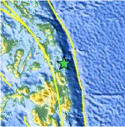
| Location | 10.019°N, 126.055°E |
| Depth | 99.8 km (62.0 miles) |
| Region | PHILIPPINE ISLANDS REGION |
| Distances | 65 km (40 miles) ENE of Surigao, Mindanao, Philippines 120 km (75 miles) SSE of Guiuan, Samar, Philippines 130 km (80 miles) NNE of Butuan, Mindanao, Philippines 750 km (465 miles) SE of MANILA, Philippines |
| Location Uncertainty | horizontal +/- 15.5 km (9.6 miles); depth +/- 3.6 km (2.2 miles) |
| Parameters | NST= 72, Nph= 74, Dmin=330.6 km, Rmss=0.97 sec, Gp= 97°, M-type=body wave magnitude (Mb), Version=6 |
| Source |
|
| Event ID | usc00010l4 |
- Did you feel it? Report shaking and damage at your location. You can also view a map displaying accumulated data from your report and others.
Earthquake Maps


Scientific & Technical Information
 Historic Moment Tensor Solutions
- Preliminary Earthquake Report
- U.S. Geological Survey, National Earthquake Information Center:
World Data Center for Seismology, Denver
