
Magnitude 5.5 - MOLUCCA SEA
2011 January 08 04:10:57 UTC
Earthquake Details
- This event has been reviewed by a seismologist.
| Magnitude | 5.5 |
|---|---|
| Date-Time |
|
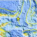
| Location | 0.067°S, 124.927°E |
| Depth | 56.3 km (35.0 miles) |
| Region | MOLUCCA SEA |
| Distances | 175 km (110 miles) S of Manado, Sulawesi, Indonesia 220 km (135 miles) ESE of Gorontalo, Sulawesi, Indonesia 1515 km (940 miles) NNW of DARWIN, Northern Territory, Australia 2115 km (1320 miles) ENE of JAKARTA, Java, Indonesia |
| Location Uncertainty | horizontal +/- 13.3 km (8.3 miles); depth +/- 0.7 km (0.4 miles) |
| Parameters | NST=146, Nph=154, Dmin=262.7 km, Rmss=1.14 sec, Gp= 36°, M-type=body wave magnitude (Mb), Version=7 |
| Source |
|
| Event ID | usc00010gr |
- Did you feel it? Report shaking and damage at your location. You can also view a map displaying accumulated data from your report and others.

Earthquake Maps


Scientific & Technical Information

 Tsunami Information
The earthquake locations and magnitudes cited in NOAA tsunami statements and bulletins are preliminary and are superseded by USGS locations and magnitudes computed using more extensive data sets.
NOAA Tsunami Bulletins for this Earthquake
No Bulletins have been issued at this time.
General Tsunami Information
- Preliminary Earthquake Report
- U.S. Geological Survey, National Earthquake Information Center:
World Data Center for Seismology, Denver
